| Top > Radio > JA prefecutres |
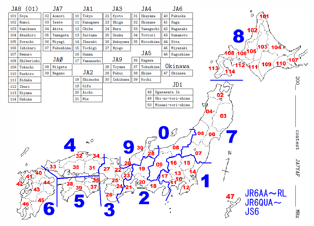
My map is here: PDF file (66KB) or PNG image file (120KB). Numbers in red are JARL prefectural numbers. There are 47 prefectures, i.e. 01-47. Hokkaido(01) has 14 subdirtricts 101-114. These subdistricts are not used for expressing addresses. JD1 (48-50) belong to Tokyo(10). These, 101-114 and 48-50 are used for JARL contests. Note that Okinawa(47) is at far southwest of Kagoshima(46), not as shown in the map.
JARL also provides a PDF file. Okinawa(47) is at `wrong' place in this map. It is more distant from Kagoshima(46).
The `another' numbers (1 to 0 from north to south) are used only for some kind of radio stations, such as community FM broadcasting stations (20W or less) and event FM stations (operated temporarily).
| District | Amateur | Other | Another | |
|---|---|---|---|---|
| Kanto | 1*1 | 2 | 3 | East of the barriers |
| Tokai | 2 | 3 | 6 | East Sea |
| Kinki [Kansai] | 3 | 4 | 7 | Near Kyoto [West of the barriers] |
| Chugoku | 4 | 5 | 8 | Central Countries |
| Shikoku | 5 | 6 | 9 | Four Countries |
| Kyushu | 6*2*3 | 7 | 0 | Nine States (though now seven pref's) |
| Okinawa | JR6*2*3, JS6*4 |
7 | 0 | Thin islands lines like a rope at offshore |
| Tohoku | 7 | 8 | 2 | Northeast |
| Hokkaido | 8 | 9 | 1 | Northern Sea District |
| Hokuriku | 9 | 3 | 5 | Northern Land |
| Sin-etsu | 0 | 2 | 4 | Shinshu and Echigo*5 |
| Ogasawara Is | JD1*6 | 2 | 3 | (name of discoverer) |
| Oki-no-tori-shima | JD1,7J1*6 | 2 | 3 | Bird Island at Offshore |
| Minami-tori-shima | JD1*6 | 2 | 3 | South Bird Island |
Long ago, i.e. more than 1,000 years before, JA3 and JA6 were the most developed areas. So JA4 which is located between JA3 and JA6 was the center of old Japan, JA9 was northern countries and JA7,8 were 'far north' countries. After a shogun moved from JA3 to JA1 in 1192, the most developed areas have been JA1 and JA3, and several barriers were built between them.
If you need more detailed, accurate or historical information for Japanese callsigns including professional stations, refer to callsign.jp.
Pronunciation: (1) For most names, fisrt syllables are pronunciated strong and high. (2) Japanese has long and short vowels. For example, `a' and `ah' are same sound, only different in length. I wrote long vowels as `ah', `oh' in the `pronunciation' column.
KCJ code is used for KCJ (The Keymen's Club of Japan) contests.
| # | KCJ | Name | Pronunciation |
|---|---|---|---|
| JA8 Hokkaido | Hok kai doh | ||
| 01 | Hokkaido | Hok kai doh | |
| JA7 Tohoku | Toh ho ku | ||
| 02 | AM | Aomori | |
| 03 | IT | Iwate | |
| 04 | AT | Akita | |
| 05 | YM | Yamagata | |
| 06 | MG | Miyagi | |
| 07 | FS | Fukushima | |
| 08 | NI | Niigata | |
| 09 | NN | Nagano | |
| 10 | TK | Tokyo | Toh kyoh |
| 11 | KN | Kanagawa | |
| 12 | CB | Chiba | |
| 13 | ST | Saitama | |
| 14 | IB | Ibaraki | |
| 15 | TG | Tochigi | |
| 16 | GM | Gunma | |
| 17 | YN | Yamanashi | |
| 18 | SO | Shizuoka | |
| 19 | GF | Gifu | |
| 20 | AC | Aichi | |
| 21 | ME | Mie | |
| 22 | KT | Kyoto | Kyoh to |
| 23 | SG | Shiga | |
| 24 | NR | Nara | |
| 25 | OS | Osaka | Oh saka |
| 26 | WK | Wakayama | |
| 27 | HG | Hyogo | Hyoh go |
| 28 | TY | Toyama | |
| 29 | FI | Fukui | |
| 30 | IK | Ishikawa | |
| 31 | OY | Okayama | |
| 32 | SN | Shimane | |
| 33 | YG | Yamaguchi | |
| 34 | TT | Tottori | |
| 35 | HS | Hiroshima | |
| 36 | KA | Kagawa | |
| 37 | TS | Tokushima | |
| 38 | EH | Ehime | |
| 39 | KC | Kochi | Koh chi |
| 40 | FO | Fukuoka | |
| 41 | SG | Saga | |
| 42 | NS | Nagasaki | |
| 43 | KM | Kumamoto | |
| 44 | OT | Oita | Oh ita |
| 45 | MZ | Miyazaki | |
| 46 | KG | Kagoshima | |
| 47 | ON | Okinawa | |